


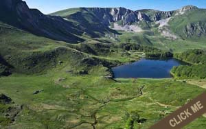
M1 - Vasojevički Kom
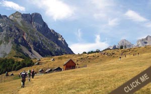
One of the best hiking tours which we recommend. It is located in the near vicinity of the hotel, tucked in attractive landscape between mountains Prokletije, Planinica and Bjelasica. Once you reach the top, you can enjoy a stunning view on all mentioned mountains. Anybody from 7 to 77 years will be able to conquer this medium easy hiking tour in not more than 2:30 hours. You can get to the start of this hiking path trough local mountain road in 45 minutes.
- Distance of track from HK: 16km
- Track length: 8,1km
- Lowest point of track: 1706m
- Highest point of track: 2461m
- Physical difficulty: 4/10
- Technical difficulty: 4/100
M2 - Mali krš
With a leisurely stroll from Andrijevica you get to village Božići, and then continue forward to Mali Krš - "small rock". During the walk, you will have a chance to enjoy beautiful natural surrounding with the occasional view on Andrijevica and nearby villages scenary. The surrounding around walking path will truly represent this place. "Small rock" - Mali Krš is located on the top of the local meadow hill with fascinating view on Andrijevica, Berane, local villages,and mountains Komovi, Bjelasica, Balj, and part of Prokletije.
- Distance of track from HK: 0.1km
- Track length: 13.5km
- Lowest point of track: 780m
- Highest point of track: 1430m
- Physical difficulty: 3/10
- Technical difficulty: 2/10
M4 - Bjelasica - Zekova glava
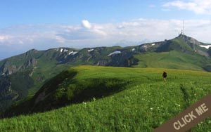
This beautiful hiking tour on the mountain Bjelasica starts from Jelovica and it can be described as moderately easy. It is characterized by the tameness, light mobility and accessibility, with richness of beauty, forests, pastures and water courses. From Zekova glava, which is the second tallest peak of Bjelasica, there is an overlook on the lake Pešić, one of the major hydrological phenomenons on this mountain.
- Distance of track from HK: 29km
- Track length: 15km
- Lowest point of track: 1260m
- Highest point of track: 2117m
- Physical difficulty: 3/10
- Technical difficulty: 2/10
M5 - Šiško and Ursulovačko jezero
Combined hiking tour covering two lakes, which are situated just six kilometers from one another. Šiško lake can be reached from Kurikuće by macadam road through forest areas and pastures, and then trough pastures and trails all the way up to viewpoint on Ursulovačko lake, which is a little less accessible.
- Distance of track from HK: 28km
- Track length:
- Lowest point of track:
- Highest point of track:
- Physical difficulty:
- Technical difficulty:
M6 - Lakes of Bjelasica
Unified hiking tour that provides an opportunity to see most of the major hydrologic phenomenons in Bjelasica such as Pešića, Ursulovačko and Šiško lake. It is a medium difficulty tour but participants need to be phisically ready because of the length of the track.
- Distance of track from HK: 29km
- Track length:
- Lowest point of track: 1260m
- Highest point of track: 2117m
- Physical difficulty: 6/10
- Technical difficulty: 3/10
M7 - Prokletije - Volušnica
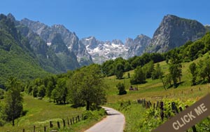
The mountain tour starts in Grbaja valley. Track leads you trough the forest to the top of Volušnica. It can be reached in two hours, and at the top you are rewarded with a stunning view on the rocky massif of Prokletije mountains and peaks of Karanfili. Tour can be further extended to nearby peaks Popadija and Karaula.
- Distance of track from HK: 46km
- Track length: 8km (11km extended)
- Lowest point of track: 1.160m
- Highest point of track: 1.879m
- Physical difficulty: 3/10
- Technical difficulty: 3/10
M8 - Prokletije - Karanfili
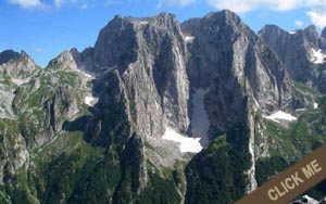
Very demanding mountain tour with the start from Grbajska valley. On the way to top of Karnfili peaks you are mastering height difference of nearly 1400m. It is recommended only for experienced and well physically prepared mountaineers. On the way there is a few points which are harder to overcome, the view from the top is so wonderful that it is worth conquering.
- Distance of track from HK: 46km
- Track length:
- Lowest point of track:
- Highest point of track:
- Physical difficulty:
- Technical difficulty:
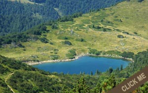
M9 - Hridsko jezero
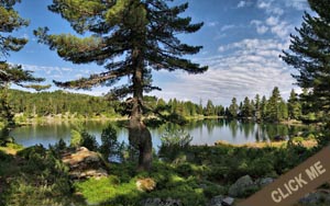
Easy walk trough paths, macadam roads, meadows, but mainly trough coniferous forests will lead you to Hridsko lake, one of the most beautiful glacier lakes in Montenegro. The track starts from Babino Polje, more accurate, from newly opened mountain home. It takes only two and a half hours to reach the lake. On the way you will see few old villages, and streams of fresh water.
- Distance of track from HK:
- Track length: 13km
- Lowest point of track: 1485m
- Highest point of track: 1970m
- Physical difficulty: 3/10
- Technical difficulty: 2/10